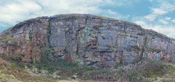
Penrhiwceiber Quarry
| Penrhiwceiber Quarry | |
 Penrhiwceiber Quarry | |
| Rock Type | Quarried Sandstone |
|---|---|
| Climbing Style | Trad |
| Approach Time | |
| Area | Sandstone |
| Sub Area | Sandstone Central Valleys |
| Geodata | |
| WGS-84 Location | 51.670347, -3.3691683 |
| OS Grid Ref. | ST 054 977 |
| WGS-84 Parking Location | |
| GR Parking Location | |
| Base Elevation | 236 metres (SRTM Estimation) |
| General Info | |
| Faces Direction | |
| Aspect | |
| Wind Sheltered | |
| Climbing Type | |
| Seepage | |
| Crags Within 5.0 km | |
|
Abercynon High Buttress, Blaenllechau, Cefnpennar, Cwmaman Main, Mount Pleasant, Mount Pleasant (X2), Mountain Ash, Mountain Ash Natural Buttress, Mountain Ash West, Navigation Quarry - Cilfynydd, Penrhiwceiber Quarry, Pontygwaith Quarry, The Gap, Troedyrhiw, Tylorstown Quarry, Upper Mountain Ash, Ynysboeth, Ynysybwl Lady Windsor Quarry, Ynysybwl Upper Quarry | |
BOLTING POLICY
New sports routes allowed.
PREAMBLE
Previously known to be a bit like 'Gandamak' (a village of Afghanistan...) it seems this place has started to be tamed a bit. The definition of ceibr in the place-name Penrhiwceiber is 'joist, beam or rafter', suggesting a place with trees suitable for being used as roof beams. This reflects the early character of the district, which up until the last twenty years of the 19th century was a heavily wooded area, its steeply sloping hillsides being covered by Penrhiwceiber woods. However the woodland nature of the district was to change with the arrival of the coal industry as the woods were felled and a colliery and terraces of houses took their place.
ACCESS
From the A4059, take the first left turn over a narrow bridge signposted to Abercynon. Continue along the narrow road with many parked cars towards Penrhiwceiber/Mountain Ash. Turn left at the Mount Pleasant Inn and follow the road up the hill until it finishes. The crag is reached by following the track up the hill (obvious). Warning - do not park right at the end of the fresh tarmac as it's someones drive..
DESCENTS
The existing routes all had lower-offs but these now seem to be in a serious state of corrosion.
THE ROUTES
1. Pickhead Arête 18m E1,5b
Start 3m left of the Arête bounding the left-hand side of the crag, and scramble up towards it, PR. Climb the arête on its right for 5m, before swinging back round left to finish. BB.
2. Edgeware 17m E4,6b
Start just right of the grassy left-hand corner of the crag, beneath a blocky groove. Climb this groove until it is possible to move directly up the slab passing 3BRs. PR, BB over on the right.
3. Landfill Project 18m E3,5c
As for 'Edgeware' to the grassy ledge, then move right, PR and go along another grassy ledge until below the second line of BRs. Climb the slab past 2BRs until it is possible to move left to a common belay with 'Edgeware'.
First Ascents
- E.Alsford, P.Donnithorne 00.00.1991
- P.Donnithorne, E.Alsford 00.00.1991
- P.Donnithorne, E.Alsford 00.00.1991