GR873740 to 884732
TIDAL STATUS
Highly variable, but never more than 3½ hours either side of low water at the east end of the cliff
and never more than 3 hours either side of low water at the west. Normally about 2 hours average either side of low
water along the cliff. Recessed areas like The Biscuit slightly longer. Some routes, especially those on Elephant Wall,
Scutch Buttress and Fire Wall have platforms which extend accessibility.
PREAMBLE
With no shadow of a doubt, Ogmore is one of the most important sea cliffs in Britain. Unsurprisingly it contains the
greatest concentration of South East Wales' best traditionally protected routes. It is wild, steep, exciting and seriously
underrated. You will either love it or hate it but whichever it is you must encounter "the Ogmore experience". Climbers
used to Pembroke will probably find it a little intimidating, but with petrol at the price it is, perhaps fiscal prudence will
overcome fear.
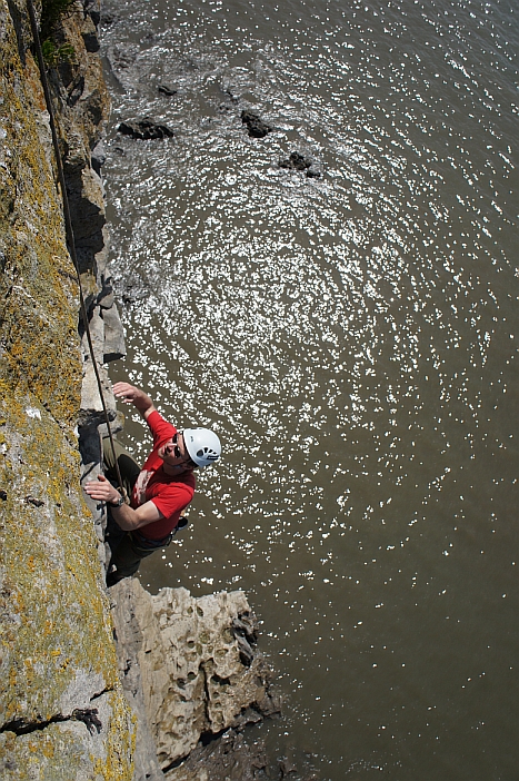
Ogmore is a limestone sea cliff situated between Ogmore by Sea and Southerndown. It offers climbing of a strenuous nature; steep, overhanging, but generally well supplied with holds. The rock is mostly good but some of the finishes may require care. It can suffer from seepage and is extremely tidal, with the tide rising 6m to 9m up the cliff, so beware of in-situ gear and use tide tables. It is a great crag for those who value adventure and excitement in their climbing, but is no place for the incompetent.
Ogmore has recently become popular as a deep-water soloing venue.Indeed some of the older hard routes where the situ gear has rotted are best done as such. Whilst it is true that there are some routes with good depths of water below them at high tide, it is important to remember that the tidal range is staggering and staggeringly variable. More importantly, the soloist should be aware that there are very strong currents hereabouts and a lot of low- level sea caves. Being swept into one of these and drowned is a serious possibility. Aspirants should always check the fall out zones at low water, before conisdering a deep water solo. The impressive deep-water solos that have been made at this crag are not listed separately unless they cover genuinely new ground, although some are mentioned in the history section.
ACCESS
To find your desired crag, type the name in to the Filter Markers box (top right corner of the map).
Loading map...
{"format":"googlemaps3","type":"SATELLITE","minzoom":false,"maxzoom":false,"types":["SATELLITE","ROADMAP","HYBRID","TERRAIN"],"limit":500,"offset":0,"link":"all","sort":[""],"order":[],"headers":"show","mainlabel":"Crag","intro":"","outro":"","searchlabel":"... further results","default":"","geoservice":"google","width":"auto","height":"600px","centre":false,"title":"","label":"","icon":"","visitedicon":"","lines":[],"polygons":[],"circles":[],"rectangles":[],"wmsoverlay":false,"copycoords":true,"static":false,"zoom":false,"layers":[],"controls":["pan","zoom","type","scale","streetview"],"zoomstyle":"DEFAULT","typestyle":"DEFAULT","autoinfowindows":false,"resizable":true,"kmlrezoom":false,"poi":true,"markercluster":false,"clustergridsize":60,"clustermaxzoom":20,"clusterzoomonclick":true,"clusteraveragecenter":true,"clusterminsize":2,"tilt":1,"imageoverlays":[],"kml":[],"gkml":[],"fusiontables":[],"searchmarkers":"all","enablefullscreen":true,"showtitle":true,"hidenamespace":false,"template":"","userparam":"","activeicon":"","pagelabel":false,"ajaxcoordproperty":"","ajaxquery":"","locations":[{"text":"\u003Cb\u003E\u003Ca href=\"/wiki/Davy_Jones%27_Locker_and_the_Sea_Caves\" title=\"Davy Jones' Locker and the Sea Caves\"\u003EDavy Jones' Locker and the Sea Caves\u003C/a\u003E\u003C/b\u003E\u003Chr /\u003E\u003Ca href=\"/wiki/Property:Is_geolocated_WGS84_text\" title=\"Property:Is geolocated WGS84 text\"\u003EIs geolocated WGS84 text\u003C/a\u003E: 51.4514745, -3.6177795\u003Cbr /\u003E\u003Ca href=\"/wiki/Property:Is_located_in_main_area\" title=\"Property:Is located in main area\"\u003EIs located in main area\u003C/a\u003E: South Coast\u003Cbr /\u003E\u003Ca href=\"/wiki/Property:Is_located_in_sub_area\" title=\"Property:Is located in sub area\"\u003EIs located in sub area\u003C/a\u003E: Ogmore\u003Cbr /\u003E\u003Ca href=\"/wiki/Property:Has_base_elevation\" title=\"Property:Has base elevation\"\u003EHas base elevation\u003C/a\u003E: 0\u003Cbr /\u003E\u003Ca href=\"/wiki/Property:Has_elevation_reference\" title=\"Property:Has elevation reference\"\u003EHas elevation reference\u003C/a\u003E: SRTM Estimation\u003Cbr /\u003E\u003Ca href=\"/wiki/Property:Has_climbing_style\" title=\"Property:Has climbing style\"\u003EHas climbing style\u003C/a\u003E: Trad","title":"Davy Jones' Locker and the Sea Caves","link":"","lat":51.4514745,"lon":-3.6177795,"icon":""},{"text":"\u003Cb\u003E\u003Ca href=\"/wiki/Dirty_Harry_Walls\" title=\"Dirty Harry Walls\"\u003EDirty Harry Walls\u003C/a\u003E\u003C/b\u003E\u003Chr /\u003E\u003Ca href=\"/wiki/Property:Is_geolocated_WGS84_text\" title=\"Property:Is geolocated WGS84 text\"\u003EIs geolocated WGS84 text\u003C/a\u003E: 51.450875, -3.615872\u003Cbr /\u003E\u003Ca href=\"/wiki/Property:Is_located_in_main_area\" title=\"Property:Is located in main area\"\u003EIs located in main area\u003C/a\u003E: South Coast\u003Cbr /\u003E\u003Ca href=\"/wiki/Property:Is_located_in_sub_area\" title=\"Property:Is located in sub area\"\u003EIs located in sub area\u003C/a\u003E: Ogmore\u003Cbr /\u003E\u003Ca href=\"/wiki/Property:Has_climbing_style\" title=\"Property:Has climbing style\"\u003EHas climbing style\u003C/a\u003E: Trad","title":"Dirty Harry Walls","link":"","lat":51.450875,"lon":-3.615872,"icon":""},{"text":"\u003Cb\u003E\u003Ca href=\"/wiki/Elephant_Wall\" title=\"Elephant Wall\"\u003EElephant Wall\u003C/a\u003E\u003C/b\u003E\u003Chr /\u003E\u003Ca href=\"/wiki/Property:Is_geolocated_WGS84_text\" title=\"Property:Is geolocated WGS84 text\"\u003EIs geolocated WGS84 text\u003C/a\u003E: 51.453131, -3.621320\u003Cbr /\u003E\u003Ca href=\"/wiki/Property:Is_located_in_main_area\" title=\"Property:Is located in main area\"\u003EIs located in main area\u003C/a\u003E: South Coast\u003Cbr /\u003E\u003Ca href=\"/wiki/Property:Is_located_in_sub_area\" title=\"Property:Is located in sub area\"\u003EIs located in sub area\u003C/a\u003E: Ogmore\u003Cbr /\u003E\u003Ca href=\"/wiki/Property:Has_base_elevation\" title=\"Property:Has base elevation\"\u003EHas base elevation\u003C/a\u003E: 0\u003Cbr /\u003E\u003Ca href=\"/wiki/Property:Has_elevation_reference\" title=\"Property:Has elevation reference\"\u003EHas elevation reference\u003C/a\u003E: Other\u003Cbr /\u003E\u003Ca href=\"/wiki/Property:Has_climbing_style\" title=\"Property:Has climbing style\"\u003EHas climbing style\u003C/a\u003E: Trad","title":"Elephant Wall","link":"","lat":51.453131,"lon":-3.62132,"icon":""},{"text":"\u003Cb\u003E\u003Ca href=\"/wiki/Fools_Fantasy_Area\" title=\"Fools Fantasy Area\"\u003EFools Fantasy Area\u003C/a\u003E\u003C/b\u003E\u003Chr /\u003E\u003Ca href=\"/wiki/Property:Is_geolocated_WGS84_text\" title=\"Property:Is geolocated WGS84 text\"\u003EIs geolocated WGS84 text\u003C/a\u003E: 51.453443, -3.622311\u003Cbr /\u003E\u003Ca href=\"/wiki/Property:Is_located_in_main_area\" title=\"Property:Is located in main area\"\u003EIs located in main area\u003C/a\u003E: South Coast\u003Cbr /\u003E\u003Ca href=\"/wiki/Property:Is_located_in_sub_area\" title=\"Property:Is located in sub area\"\u003EIs located in sub area\u003C/a\u003E: Ogmore\u003Cbr /\u003E\u003Ca href=\"/wiki/Property:Has_climbing_style\" title=\"Property:Has climbing style\"\u003EHas climbing style\u003C/a\u003E: Trad","title":"Fools Fantasy Area","link":"","lat":51.453443,"lon":-3.622311,"icon":""},{"text":"\u003Cb\u003E\u003Ca href=\"/wiki/Mitzy_Wall\" title=\"Mitzy Wall\"\u003EMitzy Wall\u003C/a\u003E\u003C/b\u003E\u003Chr /\u003E\u003Ca href=\"/wiki/Property:Is_geolocated_WGS84_text\" title=\"Property:Is geolocated WGS84 text\"\u003EIs geolocated WGS84 text\u003C/a\u003E: 51.450330, -3.614387\u003Cbr /\u003E\u003Ca href=\"/wiki/Property:Is_located_in_main_area\" title=\"Property:Is located in main area\"\u003EIs located in main area\u003C/a\u003E: South Coast\u003Cbr /\u003E\u003Ca href=\"/wiki/Property:Is_located_in_sub_area\" title=\"Property:Is located in sub area\"\u003EIs located in sub area\u003C/a\u003E: Ogmore\u003Cbr /\u003E\u003Ca href=\"/wiki/Property:Has_base_elevation\" title=\"Property:Has base elevation\"\u003EHas base elevation\u003C/a\u003E: 0\u003Cbr /\u003E\u003Ca href=\"/wiki/Property:Has_elevation_reference\" title=\"Property:Has elevation reference\"\u003EHas elevation reference\u003C/a\u003E: SRTM Estimation\u003Cbr /\u003E\u003Ca href=\"/wiki/Property:Has_climbing_style\" title=\"Property:Has climbing style\"\u003EHas climbing style\u003C/a\u003E: Trad","title":"Mitzy Wall","link":"","lat":51.45033,"lon":-3.614387,"icon":""},{"text":"\u003Cb\u003E\u003Ca href=\"/wiki/Ogmore_Popular_End\" title=\"Ogmore Popular End\"\u003EOgmore Popular End\u003C/a\u003E\u003C/b\u003E\u003Chr /\u003E\u003Ca href=\"/wiki/Property:Is_geolocated_WGS84_text\" title=\"Property:Is geolocated WGS84 text\"\u003EIs geolocated WGS84 text\u003C/a\u003E: 51.453234, -3.622041\u003Cbr /\u003E\u003Ca href=\"/wiki/Property:Is_located_in_main_area\" title=\"Property:Is located in main area\"\u003EIs located in main area\u003C/a\u003E: South Coast\u003Cbr /\u003E\u003Ca href=\"/wiki/Property:Is_located_in_sub_area\" title=\"Property:Is located in sub area\"\u003EIs located in sub area\u003C/a\u003E: Ogmore\u003Cbr /\u003E\u003Ca href=\"/wiki/Property:Has_base_elevation\" title=\"Property:Has base elevation\"\u003EHas base elevation\u003C/a\u003E: 0\u003Cbr /\u003E\u003Ca href=\"/wiki/Property:Has_elevation_reference\" title=\"Property:Has elevation reference\"\u003EHas elevation reference\u003C/a\u003E: Other\u003Cbr /\u003E\u003Ca href=\"/wiki/Property:Has_climbing_style\" title=\"Property:Has climbing style\"\u003EHas climbing style\u003C/a\u003E: Trad","title":"Ogmore Popular End","link":"","lat":51.453234,"lon":-3.622041,"icon":""},{"text":"\u003Cb\u003E\u003Ca href=\"/wiki/Phaser_Wall\" title=\"Phaser Wall\"\u003EPhaser Wall\u003C/a\u003E\u003C/b\u003E\u003Chr /\u003E\u003Ca href=\"/wiki/Property:Is_geolocated_WGS84_text\" title=\"Property:Is geolocated WGS84 text\"\u003EIs geolocated WGS84 text\u003C/a\u003E: 51.4511359, -3.6172964\u003Cbr /\u003E\u003Ca href=\"/wiki/Property:Is_located_in_main_area\" title=\"Property:Is located in main area\"\u003EIs located in main area\u003C/a\u003E: South Coast\u003Cbr /\u003E\u003Ca href=\"/wiki/Property:Is_located_in_sub_area\" title=\"Property:Is located in sub area\"\u003EIs located in sub area\u003C/a\u003E: Ogmore\u003Cbr /\u003E\u003Ca href=\"/wiki/Property:Has_base_elevation\" title=\"Property:Has base elevation\"\u003EHas base elevation\u003C/a\u003E: 0\u003Cbr /\u003E\u003Ca href=\"/wiki/Property:Has_elevation_reference\" title=\"Property:Has elevation reference\"\u003EHas elevation reference\u003C/a\u003E: Other\u003Cbr /\u003E\u003Ca href=\"/wiki/Property:Has_climbing_style\" title=\"Property:Has climbing style\"\u003EHas climbing style\u003C/a\u003E: Trad","title":"Phaser Wall","link":"","lat":51.4511359,"lon":-3.6172964,"icon":""},{"text":"\u003Cb\u003E\u003Ca href=\"/wiki/Right_Hand_Wall\" title=\"Right Hand Wall\"\u003ERight Hand Wall\u003C/a\u003E\u003C/b\u003E\u003Chr /\u003E\u003Ca href=\"/wiki/Property:Is_geolocated_WGS84_text\" title=\"Property:Is geolocated WGS84 text\"\u003EIs geolocated WGS84 text\u003C/a\u003E: 51.4499155, -3.6143329\u003Cbr /\u003E\u003Ca href=\"/wiki/Property:Is_located_in_main_area\" title=\"Property:Is located in main area\"\u003EIs located in main area\u003C/a\u003E: South Coast\u003Cbr /\u003E\u003Ca href=\"/wiki/Property:Is_located_in_sub_area\" title=\"Property:Is located in sub area\"\u003EIs located in sub area\u003C/a\u003E: Ogmore\u003Cbr /\u003E\u003Ca href=\"/wiki/Property:Has_base_elevation\" title=\"Property:Has base elevation\"\u003EHas base elevation\u003C/a\u003E: 0\u003Cbr /\u003E\u003Ca href=\"/wiki/Property:Has_elevation_reference\" title=\"Property:Has elevation reference\"\u003EHas elevation reference\u003C/a\u003E: Other\u003Cbr /\u003E\u003Ca href=\"/wiki/Property:Has_climbing_style\" title=\"Property:Has climbing style\"\u003EHas climbing style\u003C/a\u003E: Trad","title":"Right Hand Wall","link":"","lat":51.4499155,"lon":-3.6143329,"icon":""},{"text":"\u003Cb\u003E\u003Ca href=\"/wiki/The_Biscuit\" title=\"The Biscuit\"\u003EThe Biscuit\u003C/a\u003E\u003C/b\u003E\u003Chr /\u003E\u003Ca href=\"/wiki/Property:Is_geolocated_WGS84_text\" title=\"Property:Is geolocated WGS84 text\"\u003EIs geolocated WGS84 text\u003C/a\u003E: 51.4523136, -3.6186752\u003Cbr /\u003E\u003Ca href=\"/wiki/Property:Is_located_in_main_area\" title=\"Property:Is located in main area\"\u003EIs located in main area\u003C/a\u003E: South Coast\u003Cbr /\u003E\u003Ca href=\"/wiki/Property:Is_located_in_sub_area\" title=\"Property:Is located in sub area\"\u003EIs located in sub area\u003C/a\u003E: Ogmore\u003Cbr /\u003E\u003Ca href=\"/wiki/Property:Has_base_elevation\" title=\"Property:Has base elevation\"\u003EHas base elevation\u003C/a\u003E: 0\u003Cbr /\u003E\u003Ca href=\"/wiki/Property:Has_elevation_reference\" title=\"Property:Has elevation reference\"\u003EHas elevation reference\u003C/a\u003E: SRTM Estimation\u003Cbr /\u003E\u003Ca href=\"/wiki/Property:Has_climbing_style\" title=\"Property:Has climbing style\"\u003EHas climbing style\u003C/a\u003E: Trad","title":"The Biscuit","link":"","lat":51.4523136,"lon":-3.6186752,"icon":""},{"text":"\u003Cb\u003E\u003Ca href=\"/wiki/The_Castle_Area\" title=\"The Castle Area\"\u003EThe Castle Area\u003C/a\u003E\u003C/b\u003E\u003Chr /\u003E\u003Ca href=\"/wiki/Property:Is_geolocated_WGS84_text\" title=\"Property:Is geolocated WGS84 text\"\u003EIs geolocated WGS84 text\u003C/a\u003E: 51.4525004, -3.6197838\u003Cbr /\u003E\u003Ca href=\"/wiki/Property:Is_located_in_main_area\" title=\"Property:Is located in main area\"\u003EIs located in main area\u003C/a\u003E: South Coast\u003Cbr /\u003E\u003Ca href=\"/wiki/Property:Is_located_in_sub_area\" title=\"Property:Is located in sub area\"\u003EIs located in sub area\u003C/a\u003E: Ogmore\u003Cbr /\u003E\u003Ca href=\"/wiki/Property:Has_base_elevation\" title=\"Property:Has base elevation\"\u003EHas base elevation\u003C/a\u003E: 0\u003Cbr /\u003E\u003Ca href=\"/wiki/Property:Has_elevation_reference\" title=\"Property:Has elevation reference\"\u003EHas elevation reference\u003C/a\u003E: Other\u003Cbr /\u003E\u003Ca href=\"/wiki/Property:Has_climbing_style\" title=\"Property:Has climbing style\"\u003EHas climbing style\u003C/a\u003E: Trad","title":"The Castle Area","link":"","lat":51.4525004,"lon":-3.6197838,"icon":""},{"text":"\u003Cb\u003E\u003Ca href=\"/wiki/The_Western_Crag\" title=\"The Western Crag\"\u003EThe Western Crag\u003C/a\u003E\u003C/b\u003E\u003Chr /\u003E\u003Ca href=\"/wiki/Property:Is_geolocated_WGS84_text\" title=\"Property:Is geolocated WGS84 text\"\u003EIs geolocated WGS84 text\u003C/a\u003E: 51.453745, -3.622776\u003Cbr /\u003E\u003Ca href=\"/wiki/Property:Is_located_in_main_area\" title=\"Property:Is located in main area\"\u003EIs located in main area\u003C/a\u003E: South Coast\u003Cbr /\u003E\u003Ca href=\"/wiki/Property:Is_located_in_sub_area\" title=\"Property:Is located in sub area\"\u003EIs located in sub area\u003C/a\u003E: Ogmore\u003Cbr /\u003E\u003Ca href=\"/wiki/Property:Has_base_elevation\" title=\"Property:Has base elevation\"\u003EHas base elevation\u003C/a\u003E: 0\u003Cbr /\u003E\u003Ca href=\"/wiki/Property:Has_elevation_reference\" title=\"Property:Has elevation reference\"\u003EHas elevation reference\u003C/a\u003E: Other\u003Cbr /\u003E\u003Ca href=\"/wiki/Property:Has_climbing_style\" title=\"Property:Has climbing style\"\u003EHas climbing style\u003C/a\u003E: Trad","title":"The Western Crag","link":"","lat":51.453745,"lon":-3.622776,"icon":""},{"text":"\u003Cb\u003E\u003Ca href=\"/wiki/Tiger_Bay\" title=\"Tiger Bay\"\u003ETiger Bay\u003C/a\u003E\u003C/b\u003E\u003Chr /\u003E\u003Ca href=\"/wiki/Property:Is_geolocated_WGS84_text\" title=\"Property:Is geolocated WGS84 text\"\u003EIs geolocated WGS84 text\u003C/a\u003E: 51.452824, -3.620625\u003Cbr /\u003E\u003Ca href=\"/wiki/Property:Is_located_in_main_area\" title=\"Property:Is located in main area\"\u003EIs located in main area\u003C/a\u003E: South Coast\u003Cbr /\u003E\u003Ca href=\"/wiki/Property:Is_located_in_sub_area\" title=\"Property:Is located in sub area\"\u003EIs located in sub area\u003C/a\u003E: Ogmore\u003Cbr /\u003E\u003Ca href=\"/wiki/Property:Has_base_elevation\" title=\"Property:Has base elevation\"\u003EHas base elevation\u003C/a\u003E: 0\u003Cbr /\u003E\u003Ca href=\"/wiki/Property:Has_elevation_reference\" title=\"Property:Has elevation reference\"\u003EHas elevation reference\u003C/a\u003E: Other\u003Cbr /\u003E\u003Ca href=\"/wiki/Property:Has_climbing_style\" title=\"Property:Has climbing style\"\u003EHas climbing style\u003C/a\u003E: Trad","title":"Tiger Bay","link":"","lat":51.452824,"lon":-3.620625,"icon":""},{"text":"\u003Cb\u003E\u003Ca href=\"/wiki/Tusker_Chimney_Area\" title=\"Tusker Chimney Area\"\u003ETusker Chimney Area\u003C/a\u003E\u003C/b\u003E\u003Chr /\u003E\u003Ca href=\"/wiki/Property:Is_geolocated_WGS84_text\" title=\"Property:Is geolocated WGS84 text\"\u003EIs geolocated WGS84 text\u003C/a\u003E: 51.452948, -3.621156\u003Cbr /\u003E\u003Ca href=\"/wiki/Property:Is_located_in_main_area\" title=\"Property:Is located in main area\"\u003EIs located in main area\u003C/a\u003E: South Coast\u003Cbr /\u003E\u003Ca href=\"/wiki/Property:Is_located_in_sub_area\" title=\"Property:Is located in sub area\"\u003EIs located in sub area\u003C/a\u003E: Ogmore\u003Cbr /\u003E\u003Ca href=\"/wiki/Property:Has_climbing_style\" title=\"Property:Has climbing style\"\u003EHas climbing style\u003C/a\u003E: Trad","title":"Tusker Chimney Area","link":"","lat":51.452948,"lon":-3.621156,"icon":""},{"text":"\u003Cb\u003E\u003Ca href=\"/wiki/Twinkle_Buttress\" title=\"Twinkle Buttress\"\u003ETwinkle Buttress\u003C/a\u003E\u003C/b\u003E\u003Chr /\u003E\u003Ca href=\"/wiki/Property:Is_geolocated_WGS84_text\" title=\"Property:Is geolocated WGS84 text\"\u003EIs geolocated WGS84 text\u003C/a\u003E: 51.4535262, -3.6225426\u003Cbr /\u003E\u003Ca href=\"/wiki/Property:Is_located_in_main_area\" title=\"Property:Is located in main area\"\u003EIs located in main area\u003C/a\u003E: South Coast\u003Cbr /\u003E\u003Ca href=\"/wiki/Property:Is_located_in_sub_area\" title=\"Property:Is located in sub area\"\u003EIs located in sub area\u003C/a\u003E: Ogmore\u003Cbr /\u003E\u003Ca href=\"/wiki/Property:Has_base_elevation\" title=\"Property:Has base elevation\"\u003EHas base elevation\u003C/a\u003E: 0\u003Cbr /\u003E\u003Ca href=\"/wiki/Property:Has_elevation_reference\" title=\"Property:Has elevation reference\"\u003EHas elevation reference\u003C/a\u003E: Other\u003Cbr /\u003E\u003Ca href=\"/wiki/Property:Has_climbing_style\" title=\"Property:Has climbing style\"\u003EHas climbing style\u003C/a\u003E: Trad","title":"Twinkle Buttress","link":"","lat":51.4535262,"lon":-3.6225426,"icon":""}]}
The layout of Ogmore is difficult to get to grips with and abseil in is the most practical way of approach. However, due
to the tides, escape can be difficult, without a little forethought. It is therefore strongly recommended that climbers
unfamiliar with the cliff view the familiarisation page. There are two approaches from the road. The
western approach is the most useful, for anything to the west of Mother Earth. For the eastern end of the crag, the
Southerndown Approach is more useful, but a parking fee is due at some times of the year. Most climbers who are
familiar with the crag will tend to abseil in from various points. These are noted in the Crag Familiarisation Page, but
be warned that the stakes are of unknown origin or age; always find a way to back them up.
1. Western Access
Follow the B4524 from Ogmore by Sea towards Southerndown (Dunraven Bay) until it reaches a sharp bend passing
West Farm (just after the sign marking the boundary of Southerndown). Park above the cliffs in a grassy area bounded
by concrete post next to the "Barn". Descend a grassy gully towards the sea to reach
a narrow path running westwards. When facing out to sea, a pinnacle is visible to the east (left). This marks the start
of Exposure Explosion and is more or less directly above the line of Jumping Jack Flash.
2. Southerndown Access
Follow the B4524 a little further to a sharp left-hand bend at the "Three Golden Cups" pub, but go straight on down the smaller road sign-posted "Beach". Park in the car park at the base of the hill (parking fee in spring and summer) and walk out to the concrete slipway. Turn back west (right if facing out to sea) to walk into the crag. Note that it is only
possible to walk all the way along the base of the cliff at dead low water on spring tides, due to the cut off points round Davy Jones' Locker and Scutch.
DESCENTS
See Ogmore Crag Familiarisation and by abseil.
The Areas of Ogmore
Routes are described from left to right when facing the crag from the base.
Additional access notes (to the crag familiarisation page) are provided here to locate the areas from above (looking out to sea).
Parking is best either side of The Barn at West Farm, a masonry cafe/bar on the cliff side of the road. The western parking spot is directly above a dry valley which leads to the pinnacle above the start of Exposure Explosion. The eastern parking spot is above the Buiscuit/Hardy's Bay. The Fire Wall end of Tiger Bay lies approximately half way between either parking spot.
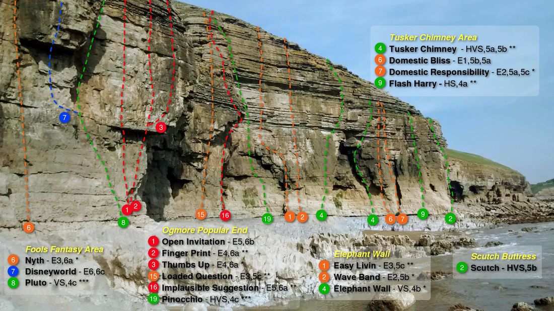
- Twinkle Buttress
The top of the buttress is a flat and relatively wide platform at the lowest point of the cliff. There are numerous pegs, stakes and situ gear to abseil/belay from.
Above the platform a walkway extends left (east) for about 25m, contains a few pegs
on the back wall for belays, and ends at a grassy gully. The gully marks the eastern end of the large sea level cave and lies between the routes Fools Fantasy and Wipeout.
- Fools Fantasy Area
Access Fools Fantasy and routes to its west from Twinkle Buttress, access Wipeout and routes to its east from stakes and pegs above the Popular End.
- Ogmore Popular End
From the grassy gully at the eastern end of the Fools Fantasy Area are a stake and two pegs on three distinct outcrops approx 10 back from the cliff edge. The stake is directly above the exit of Nyth, the pegs above Open Invitation and Thumbs Up respectively.
Pages in category ‘Ogmore’
The following 25 pages are in this category, out of 25 total.

