Stout Point
From South Wales Climbing Wiki
| Stout Point | |
 Stout Point Cave | |
| Rock Type | Natural Jurassic Limestone |
|---|---|
| Climbing Style | Sport |
| Approach Time | 20 minutes |
| Area | South Coast |
| Sub Area | Llantwit Coast |
| Geodata | |
| WGS-84 Location | 51.392084, -3.478126 |
| OS Grid Ref. | SS 972 669 |
| WGS-84 Parking Location | 51.401238, -3.484858 |
| GR Parking Location | SS 968 679 |
| Base Elevation | 0 metres (Other) |
| General Info | |
| Faces Direction | South |
| Aspect | |
| Wind Sheltered | |
| Climbing Type | Serious |
| Seepage | |
| Tidal | |
| Before/After Low Tide | 3.0 hours (See Note) |
| Crags Within 2.0 km | |
Contents
BOLTING POLICY
PREAMBLE
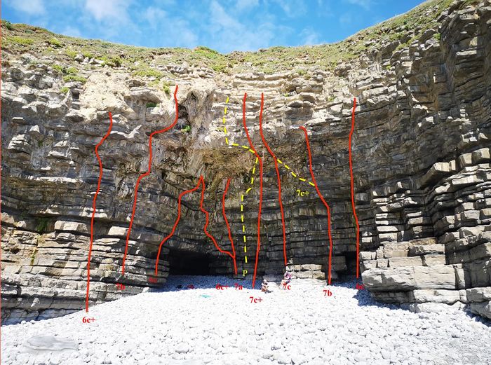
Steep, very steep sea cave. Warm up on the 6c+ then launch into the 7s. 2hr tidal window either side so 4-5 hrs if you are lucky. Try not to get cut off by the varying tides/swell. Escape west unless you fancy a long walk.
ACCESS
Park at the end of Mill Lane. Walk past Rosedew Farm to the coast path, walk east a short way from the stranded kissing gate. Descend Fisherpersons' Ledges (9 routes here). Walk 300yds W to Far West Wing (13 routes). Approach and escape the very tidal Stout Point from/to the west (passing the West Wing). The cave is set into the point.
THE ROUTES
A topo by Rob Lamey can be downloaded. https://swcw.org.uk/testwiki/dloads/stout_point_topo.pdf
First Ascents

