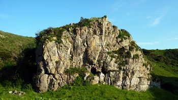
Richards Rock
| Richards Rock | |
 | |
| Rock Type | Quarried Carboniferous Limestone |
|---|---|
| Climbing Style | Undeveloped |
| Approach Time | 10 minutes |
| Area | Gower |
| Sub Area | Rhossili |
| Local Area | Upper Crags Fall Bay To Mewslade |
| Geodata | |
| WGS-84 Location | 51.563522, -4.276806 |
| OS Grid Ref. | SS 422 874 |
| WGS-84 Parking Location | 51.565848, -4.270856 |
| GR Parking Location | SS 427 876 |
| Parking Postcode | SA3 1PH |
| Base Elevation | 20 metres (Other) |
| General Info | |
| Faces Direction | West |
| Aspect | Partially Sunny |
| Wind Sheltered | Mostly |
| Climbing Type | |
| Seepage | |
| Crags Within 400m | |
|
Block Buttress, Catacomb Gully, Four Gullies, Grey Wall, Mewslade Quarry Slab, Mewslade Short Wall, Richards Rock, Thurba West, Trident Gully and Ridge, Zero Gully | |
PREAMBLE
ACCESS
From the main Rhossili road, turn left in Pitton (south) to Great Pitton Farm (SS 427 876 or 51.556076, -4.267799) where there is a car park. The honesty box no longer exists and a system of seasonal tariffs is now in operation. Payment is made via a machine or paybyphone Ⓡ. See Pitton Parking for information on charges. Currently a maximum of £5.00 is charged for parking from 06.00 to 22.00.
On walking out of the car park, turn left and, after about 25 metres take the public footpath off to the right. Pass through a gate after about 15m and then follow the rough path for a further 200m where there is another gate. This is the top end of Mewslade.
Continue straight on and follow the path down the valley for approximately for 270 m. Richards rock is just to the left and can be accessed through a gate in the stone wall.
THE ROUTES
First Ascents